Friday, April 30, 2010

Spirits in the Sky


For the past couple of nights I've been taking advantage of both some beautiful night skies and the low-light capabilities of my new Canon 5D Mark II camera. This camera is just awesome for making night images. The image above is a 30 second exposure taken at ISO 3200, which I never could have done with my old camera. The old camera at ISO 3200 would have had so much noise that the image would have been unusable. By using such a high ISO setting, the camera was also able to pick up the Milky Way in the image.


The image above is a 2 hour exposure made between 11:00 p.m. and 1:00 a.m. This image was shot at ISO 100, but even with such a low ISO setting, at 2 hours most cameras would still be producing unacceptable noise levels. Not so with the 5D Mark II! The image is very clean, with very acceptable noise levels. It should be noted that in the above image, the glow of light on the horizon is not from the sun or the moon, but rather from the city lights of Thunder Bay, Ontario, which is about 40 miles away.

The image below was a 1.5 hour exposure, taken this time from 2:30 a.m. to 4:00 a.m. This time of year, by 3:30 a.m. the sky is already starting to show signs of light from the coming sun, and by running the exposure until 4:00 a.m. the final image looks almost like the blue sky that you see during the day.

Thursday, April 29, 2010

Wagon

I'm sitting on what I think is part of an old wagon for hauling out the logs that were cut in this little canyon all those years ago.

Wednesday, April 28, 2010

Cats


I was posting a photo and a little info on each of my 6 horses, 3 dogs, and -opppps - I didn't do the 3 cats. (I think I got sidetracked by the eclipse and the shipwrecks.) We do have 3 cats. Only 3 at this time. The number of cats has varried over the years. We went as high as 7 at one time, but that is way to many for one house. Now we are back to 3 which is a much more managable number to have. I think the first pet I ever had was a dog. A rough coat Collie named Sport. I know there are photos of me with him when I less than a year old. He had been my granddad's dog but when he died just before I was born my parents took him. He wasn't a young dog even then.
After that there were a string of cats. I don't remember them but there were a few photos. I don't know why, but I really love cats. I have done without cats, dogs, and horses, for years on end in my life (and managed to live over it) but I don't think I could ever do without a cat again. I love my horses and dogs dearly but cats are really special. I don't think I have been without a cat since I was about 14 years old. That was a long time and a total of 20 different cats. Some didn't make it very long for one reason or another. But most have lived a long life to go on to a well deserved place in Cat Heaven. Right now we have Jade, K.C., and Murphy. This photo is of K.C. . Eight years ago she came to the door as a tiny kitten, screamed and screamed that she needed to live with us and finally had her way. We don't know where she came from and couldn't find anyone to claim her, so she became one of the family. Her name is short for Kitty Cat. Named by my then teenage son. Now isn't that orginal. K.C is the kind of cat that regardless where she decides to lay down she can look totally and completely comfortable. With all the cats I have had, and cats are known for looking comfortable, K.C. takes it to extreames. I just wish I could do as well at relaxing as she does. K.C. is also, an excelent mouser, and gets along better with the dogs than the other two cats do. In fact she is not sociable with the other cats at all. Even after knowing Jade, (who is 10) all her life and Murphy ( who is 5) all of his, she still hisses, and spits at them if they come close to her. She diffently perfers the company of my husband and myself over other cats, but will run and hide if we have visitors.

Monday, April 26, 2010

Warrants. Surveys. Patents :: Locating the Land of Hans Jacob Brubacher

A wonderful article was published in the January 1986 issue of "Pennsylvania Mennonite Heritage" titled "Hans Jacob Brubacher, Fraktur Artist" which was written by David R. Johnson. I received the article in 1999 from a distant cousin, Margery Bebow, who is related through both the Brubaker and Foster lines. She had received the article from another distant cousin, Ken Fawley, who happens to be married to my 1st cousin Caroline Conrad.


The seven-page article presented what was known about the three generations of men named Hans Jacob Brubacher who lived in what was then Martic Township (now Providence Township) in Lancaster County, Pennsylvania from about 1730 through 1817. Information from Mr. Johnson's research in land and estate records combined with that from Phares Brubaker Gibble's "History and Genealogy of the Brubaker, Brubacher, Brewbaker family in America" provides a good summary of the family, though with at least one error, which may be the subject of a future post.


Hans Jacob Brubaker III is my 5th great-grandfather. His father, Hans Jacob II - the Fraktur Artist, is my 6th great-grandfather. His father, Hans Jacob I, is my 7th great-grandfather.


In his will (dated June 24, 1754 and recorded in Lancaster County Will Book 1 pages 89-90) Hans Jacob Brubacher identified himself as a weaver. Proved on April 17, 1755 the will stated that he owned real estate but did not provide a location or description of the land.


On page 11, the author of the Fraktur Artist article cites several passages from "History of Lancaster County, Pennsylvania, with Biographical Sketches of Many of Its Pioneers and Prominent Men", by Franklin Ellis and Samuel Evans (Philadelphia: Evens & Peck, 1883), p. 868:


The elder Hans Jacob acquired 124 acres of land through agents John Herr and Martin Kendig in 1730, "about one mile due southwest from the present village of New Providence, near Big Beaver Creek."

The author continues by saying (emphasis added):


A more garbled account by the same authors gives similar information in a history of the town of New Providence: "A man by the name of Powpather had a large tract of land close by, if not altogether in the limits of the present village. His land extended westward. When he divided his land among his children he changed the name on their deeds to 'Brubaker.'"

Mr. Johnson goes on to say:


The location of the first Jacob Brubacher's land is still uncertain. The most probable tract is the one consisting of 318-plus acres, for which Henry Herr obtained warrant, survey, and patent in 1762 and which was located one mile or more south-southwest of the village of New Providence.

In the footnote for the above statement, citing Patent AA-3-296 and Survey C-76-209, the author states: "As yet no patent, survey, or deed for the elder Jacob Brubacher has surfaced."


Referring to the will and the estate of the elder Hans Jacob, Mr. Johnson states:


"The deceased owned about 150 acres in what was then Martic Township. Because his personal estate was insufficient to pay all expenses, a sale of 60 acres of his land was contemplated, but the family later agreed to sell the whole tract. Jacob Graeff was the highest bidder of £114 at the sale which took place on April 27, 1757, but the court refused to confirm the sale when Thomas Smith, a local resident, appeared and claimed that others present at the bidding did not have time to submit their bids. On December 31, 1757, another sale was held on the premises. This time Henry Herr purchased the farm for £130 5s. and agreed to take responsibility for the widow's bequeathments. When the estate was settled, a final balance was equally divided among the four inheriting children, each of whom received £17 10s. 9d. Henry Herr may have been a close friend or relative; the year before the sale, minor child Abraham Brubacher chose him as guardian."

While looking for county and state resources available online for Pennsylvania in preparation for on-site research in the areas where several ancestors lived, I "discovered" the awesome website of the Pennsylvania Historical and Museum Commission, particularly the Land Records Portal associated with the State Archives.


Available online through the above mentioned Land Records Portal are digital images of land warrants, surveys, patents, warrantee township maps, and other associated state-level land records from the 1680s to the present day. They DO NOT have the deed books for transactions "transferring land between private citizens that occurred either after or during the patenting process." Those records are maintained at the office of the Recorder of Deeds for the appropriate county.


Some image sets, such as the warrantee township maps, do not include coverage for all counties or even all townships within a county. It does get a little confusing, since there were so many county boundary changes, and it takes time to figure out what you're looking for and then even determining what you are looking at. But it is well worth the time it takes.


Sometimes a warrant was issued but the patent wasn't filed until many years later. Such was the case of the land of Hans Jacob Brubacher II. One warrant for his land was dated July 20, 1748 and another on March 9, 1759 but the patents were not issued until February 23, 1813.


I first looked at the Warrantee Township Maps. There are very few available for the counties where my ancestors settled, but there just happened to be one for Providence Township, Lancaster County. These maps show all original land purchases from the Proprietors or the Commonwealth that were made within the boundaries of present-day townships. The warrants and surveys will generally be found in the county at the time they were issued. Like I said, it does get a bit confusing!


The maps are large pdf files. This one was 7.5mb and I imagine the original was several feet wide. You have to enlarge the map considerably to be able to read the text. Then you look through the names on the map to find your person(s) of interest. The numbers in the upper left of each entry indicate the location on the map. I was looking for Jacob Brubaker but was pleasantly surprised to find the name of Thomas Stoneroad also.


According to the Phares Gibble book (page 76) Jacob Brubaker III married Elizabeth Stoneroad. Records show that the surname was originally Steinweg or Steinweeg. The surnames seem to have been used interchangeably for a period of time in the 1780s through the early 1800s. Apparently "stein" is a German and Norwegian word meaning "stone" or "rock" and "weg" means way or road. Thus Stoneroad is the anglicized equivalent of Steinweg.


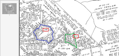
Above is a very small portion of the Warrantee Township Map for Providence Township (double-click the image to view a larger version). The area outlined in blue is the location of the land of Jacob Brubaker II, which was inherited by Jacob III. The area outlined in green is the tract of Thomas Stoneroad.


Below is survey C-16-89 for Jacob Brubaker (II). The text reads:


A Drought of a Tract of Land Situate in Martick Township in the County of Lancaster Containing in the whole 107 as & 166 pr & the usual allowance of Six P Cent for the Roads &c 72 as & 76 pr & the usual Allowance Surveyed in pursuance of a warrant dated the 8th of March AD 1759* Granted unto Jacob Brubacker and 35 as & 90 pr and the usual Allowance, being part of a Larger Tract Containing -


Surveyed in pursuance of a Warrant dated the 8th of March AD 1759 Granted unto Thomas Smith &c Surveyed the above tract of Land for Abraham Brubaker the 11th day of January AD 1810.


Jacob Hibshman D.S.

* Brubacker's Warrt is Dated 20 July 1748


Survey C-16-89 for Jacob Brubaker.
I also looked up the survey for Thomas Stoneroad. The surname is unique enough that I've been gathering whatever information I can find on anyone with that surname.


Survey C-201-16 for Thomas Stoneroad.


His tract of land is 42 acres. But what I found very interesting is that his name is associated with the tract labeled A-51-104, which is the survey number. So, yeah, I grabbed that one too.


The original survey A-51-104 is for Jacob Prowpather!


Yes! This is the record that had previously not been found! And I wouldn't have found it either if I hadn't looked at the survey for Thomas Stoneroad. Luckily, my friend Cindy was at home with me at the time and I was able to share this discovery with her, though I'm sure I didn't explain it all very well. It was just nice to be able to talk it over with someone else who "understands" these things!


The document text reads:


Jacob Prowpather 124 acres & the allowance of Six pcent situate on a Branch of Beaver Creek in the County of Lancaster Surveyd to him in right of Martin Kendrick & John Heer [sic: Herr], the 4th of November 1730.


Jno. Taylor.


Warrt. 22 November 1717.

Returned &ca. Novr. 29th 1764 for the use of Martin Funk in pursuance of a Warrt. dated the 26th day of Novr. 1764 now Situate in Martick Township in the County of Lancaster.

No Warrant or Patent was found for this land in Lancaster County or Chester County in the name of Jacob Prowpather or Jacob Brubaker or other variations of the surname. (Lancaster County was a part of Chester County until 1729.) I didn't really expect to find either record since the tract was "in right of" Kendrick and Heer.


Records at the county level will have to be checked to find the deeds for when Jacob sold the land and for Thomas Stoneroad's purchase of the land.


Looking at the Warrantee map once again, we see that the land identified as survey A-51-104 (outlined in red) belonged to Martin Funk and is the same property originally owned by Jacob Prowpather, aka Jacob Brubaker (the 1st) from 1730 until his death in 1755. The land that Thomas Stoneroad obtained in 1804 is outlined in green, and that of Jacob II (and III), which they owned from 1748 to about 1817, is outlined in blue.


In his article, David R. Johnson included two diagrams of the property of Jacob II, one of which placed the property in a present-day (1986) map. Using his drawings and Google Maps, I was able to locate the Brubaker tracts on a road map and on a satellite view.


That dark line running from the left-center and curving down the lower-right of the image is the Enola Low Grade Trail, which opened last year. I may just have to check that out (amongst other things) on my way through Pennsylvania this coming week!


I haven't gotten through the entire list of Pennsylvania ancestors yet, but I have found warrants, surveys, and patents for the lands of 12 of them! All in all, the last couple of days have been very productive...


Sunday, April 25, 2010

Oh! Canada...

This post is being brought to you from the Tourist Information Center in Grande Cache, Alberta, Canada! (Refer to the Map to see where that is... north of Route 16, about halfway to Grande Prairie on the road not shown.) I'm now into my third full day in this beautiful country and have managed to travel a little over 500 miles. It is a gorgeous day. Sunshine and blue skies, though a bit hazy but with no clouds.

When I arrived at the Roosville Port of Entry (north of Kalispell, Montana on US 93) at 4:20 pm on July 28th, there were a dozen vehicles and two motorcycles in line ahead of me. Fortunately the wait wasn't long. Fifteen minutes and a few questions later I was in British Columbia, Canada. The questions? Was I carrying: any firearms, anything I was going to leave behind in Canada, currency of any type valued at more than $10,000 Canadian, any alcoholic beverages? He also asked where I was going and what route I was taking to get there – it's a good thing I finally got around to figuring that out before I crossed the border!

According to the map I have, there were several Provincial Campgrounds within the first hundred miles. I stopped at the first one, called Kikomun Creek, about 20 miles from the border. It looked to be more like a resort since many of the RVs had decks or patios alongside them. I was quite relieved when the nice lady camp host said she had a spot for me. It was a nice place with friendly people. The sun was shining and it was in the upper 80s but there was a nice breeze and my camp site was in the shade. Ya can't ask for anything better!

It started raining just after sunset along with some thunder and lightening and then it rained most of the night, but I didn't care since I wasn't out in it! However, there were scattered showers along the 200+ miles I drove on Thursday. Cloudy skies with intermittent rain and a bit of sunshine. The scenery more than made up for the weather!

Upon entering Kootenay National Park at Radium Hot Springs, the sun was shining once again. This view of the Kootenay Valley is about half-way through the park. (Please, double-click on the images to view a larger version.)

This is half of Two Jack Lake, near Banff, taken between rain showers. I think it is the west half but my sense of direction got totally confused with the drive up there! At Two Jack Lake there is a lakeside campground and then there is the other one. The former was full but there was plenty of sites available at the other one, which is where I spent my second night in Canada.

Shortly after leaving Kikomun Creek Campground I saw a moose with her calf crossing the highway. There were a lot of deer grazing alongside the road. In Kootenay Park there were a group of about a dozen mountain goats, several quite small, near one of the pullouts on the other side of the road.

The drive through Banff and Jasper National Parks was amazing. I'll have some more pictures later (very slow internet connection) but they aren't all that great since the weather wasn't cooperating. It was cloudy and overcast most of the two days I spent there.

Photographs taken on July 29, ...

Wednesday, April 21, 2010

Redwood Forest


Redwood Regional Park, originally uploaded by ParsecTraveller.

Another photo from today's visit to Redwood Regional Park. This park is just minutes from Oakland, and a short drive from the inland East Bay.

It was 98 degrees inland today; at Redwood, it was 83. Talk about relief from the heat!

Monday, April 19, 2010

Lucky

Ride Studio Cafe, Sunday Ride
Overheard while doing errands in a local suburb:


Woman Walking Out of a Gym: Oh, what a nice bike!


Woman on a Roadbike: Thank you.


Gym Woman: How lucky you are to have time to bike. I wish I could, but after work and cooking dinner I'm just exhausted.


Bike Woman: Oh I'm sorry. But it's nice that you get to go to the gym, isn't it?


Gym Woman:Sure. But, you know, I have to. It's such hard work!


Bike Woman:How often do you go?


Gym Woman: Hmm... Four days a week I guess?


Bike Woman: Oh wow. And how long is your work-out?


Gym Woman: Usually an hour. Sometimes the pilates class is an hour and fifteen minutes.


Bike Woman:That's impressive. And how long does it take you to get there and back?


Gym Woman:What? Oh, I don't know. Let's see... maybe 20 minutes in the car?


Bike Woman: Each way?


Gym Woman: Yeah, I guess so.


Bike Woman:Well you know, my bike rides are only 2 hours long - you can ride a bike instead of going to the gym if you want and it would be the same.


Gym Woman (giggles nervously): Really? No, that can't be right. I'm only at the gym for an hour. Plus I haveto work out or else I gain weight like crazy... You're lucky you're so thin...

It's hard not to feel defensive when receiving backhanded compliments about how "lucky" we are to have all this supposed free time to ride a bike. I've gotten plenty of comments like this. But I have never, not once, heard the same reasoning applied to people who go to the gym on a daily basis. After all, the gym is "hard work" and going shows that the person is disciplined and responsible about staying fit. Cycling on the other hand, apparently shows that we have too much leisure time. It is not logical, and it is not "fair," but the perception is nonetheless there, and I think it goes a long way toward explaining why non-cyclists dislike cyclists - roadcyclists in particular. Lucky us indeed.

Wednesday, April 14, 2010

The Buff?


30 years ago half of the gear available off the rack in Snells couldn't be had in the US. Half the climbing gear available in the US no one wanted.


Things have changed. Maybe 5% of the gear available in the US is hard to find in Europe and nothing in Snell's can't be had in the US these days. And when you do find it, itis generally cheaper. Although some of it might take a bit of searching.


So what does all this have to do with a Buff? They are big, mean and generally like to be left alone. Mess with them at yourown peril. The burnt and salted earth approach.


First I had heard of THE"Buff" was after a little apre ski at the apartment in Cham. We meet a couple of the local live inBrits just afterlunch at the Requinhuton the VB as they skied by from simu soloing Laratoune. They in turn cheerfully helped us through our stock of wine and beer back at the flat. Couple days later someone wanted to know if they had left their "buff" behind. Iguessed, correctly it seems, it was one of those retro '70s, lycrahead band thangs that were so fashionable in Chamonix.


Figured it was "only" a Chamonix thing so I bought my buddies one each for grins before we left town.


I earned my retro '70s style. Cotton bandanas, wool scarfs of assorted colors, leather head bands. Used them all to good effect with a full head of hair. Often times they required attire bitd.So not uncommon for me to turn up looking. as my wife describes it, like a "muffin head".Which almost, but not quite, squishes my ego. But not my now white, muffin head! Admittedly only half cool with a buzz cut but workable. Yes they work well under a helmet to keep your ears warm. Yes there really are 12 ways to wear one. Pirates, banditos and real men will use only 4.


The "Buff" is made in Barcelona, Spain, of 100% mirco fiber polyester (or Merinowool) and available in every color the rainbowand most patterns you cna imagine at your local REI of all places (or Technique Extreme) for 15 Euro or $20 US for the polyester versions. The cheap knock offswill squish a grown man's head. They dohow ever make most of uslook a bit like a urban camo'edBuff and may be even a bit of a colorful muffin head.


Get alittle style! And add a little color to you shady life style andyour buddy's photos. Get a Buff! Hell, get two and mix it up!


http://www.planetbuff.com/Original-Buff?page=all


Fook'um I earned my muffin headand liked lycra 30 years ago! The colors may fade but a trulyclassic style,doesn't ;-)


Now who is making a good knicker again and bell bottoms...ya, we need some Shoeller bell bottoms!

Monday, April 12, 2010

Mt Erie ..

Steve and I decided on doing some rock climbing at Mt. Erie on Monday. Skies were to be clear, and temps around 40° up in Anacortes. This was our choice after being somewhat tired from our Saturday climb, and not thinking the skiing was going to be all that great.

We had a leisurely start to the day, and left Edmonds around 8:30am. Our intention was to climb in the Snag Buttress area of the mountain, and check out some new (to us) routes in that area. Steve's main interest was in the route Touching the Sky, a 5.9 sport route accessed from Snag Buttress. That meant climbing the first pitch of Zig Zag (5.7) to get there. Once on the ledge, we determined that the down climb, and water seep on the route meant we did not want to do it. Instead we opted to climb up the ledge slightly above the top of Snag Buttress where there were multiple routes to chose from. We opted for the Ray Auld Memorial Route (5.7) which brought us up to the top of wall.

We hiked around a bit trying to make sense of the maps and crags. We stumbled upon a short blocky sport route which I am thinking might be A View to a Climb (5.6) on the Lumpy Crag. Hard to tell. We climbed it, and just west of the top we were above the Friction Slab area. After that, we played the typical Mt. Erie find the best way down game. We looked through the book and followed some weak trails down. (Made more fun by walking on slippery grass with rock shoes.) A free-hanging rappel off a Madrone tree and some bramble bushwhacking got us back to the packs.

It was a fun day. However, I seemed not mentally up to the climbing and had difficulty at times with moves/grades that are well within my ability. Also of note, was the generally crummy rock quality and lack of good protection in some areas. Plenty of relic pitons and old bolts around too.

Coming up Zig Zag (photo by Steve Machuga)

Steve leading up Ray Auld

Show off

Sunday, April 11, 2010

Hot Wire

This is called the Tumbleweed Crossing and it is tumbleweed time. The tumbleweeds are growing ----- well, their growing like weeds. Actually they are not a 'weed'. Weed means any plant that is unwanted in your patch of the woods or in my case the desert. Tumbleweeds or Russian Thistles were brought to the United States as cattle fodder. People can eat them if picked young and tinder. I would think you could cookthemin a pot of greens or stew or maybe have them added to a salad.(I've never tried them.)

Regardless the horses love them. And since they are growing well at this time of the year my mares are trying their best to get to each and every one. Tumbleweeds make a good treat for the horses if you dare to pull one. I can't understand why the horses want to eat something that has so many stickers on it after it is more than a week old.

My mare, Nita, thinks her neck will stretch out like a giraffe and she can reach the ones on the outside of her pen. She leans over the fence, pushing on the posts to reach them and gradually pushes the fence down. Star prefers to reach under the fence, and frequently has scratches on her face where she scrapes it on the wire fence.

We spent yesterday replacing a couple of broken fence posts, pulling the wire back up into place and checking out the hot wire we have run around the top of the fence that hasn't been used since last summer.

The electric wire works and now the horses are not trying to get at the tumbleweeds on the outside of their fences.


I was leery of using it with Star since she is blind, but the horses seem to be able toknow when the wire is hot and when it isn't. Don't know if they can feel it or hear it or what. Anyway I didn't see either of them touch it but now they don't get more than 3 inches from the wire.

Thursday, April 8, 2010

Spring break

I took a break from the recent gray days and worked on some pictures from last spring. This is the same garden from the Shoals Garden Tour that I posted about before. The "more pictures later" part only took me eight short months! Oh well.


I'd never been on a garden tour, so I wasn't sure what to expect. But this garden alone was worth the price of the tour. It's difficult to believe that all of this was on 3/4 acre.


Calla lily.


So much of what I love about this garden is the hardscaping. This purple wall was a favorite feature, and if I ever build a garden, I'm now convinced that I'd want to include a lot of statuary. (I think this is Apollo.)


Piney path.


Cherub planter.


Shady rest.


From the more traditional front of the house, you'd never guess that all that was going on in the back.

The garden has its own web site.

Tuesday, April 6, 2010

Assateague Island National Seashore

It was as if I had entered a different country. Indeed, I had. Driving south on Route 213 on Sunday morning (October 18th) from Elkton, Maryland, the land became more rural and flat. No more big hills. Traffic was nearly non-existent. A welcome relief from the hustle and bustle driving of the past few days. It was still raining but from the weather reports I was hearing on the radio, I had missed the worst of it. By early afternoon the rain stopped, the clouds were clearing though the sun had yet to make an appearance. There were reports of flooding in the low-lying areas along the eastern shore so I stopped early for the night.

Monday morning brought clear blue skies and sunshine, a glorious morning though cold with temps in the 40s, but at least it wasn't raining! In just a few hours I arrived at the Assateague Island National Seashore south of Ocean City, Maryland. There were areas that were flooded due to all the rain they had received and some of the campsites were affected. I drove around the “loops” in the bayside campgrounds managed by the National Park Service and located the “perfect” spot. It was a relatively large site with a view of the bay and just a small low area, close to the bay, that was filled with water.

That afternoon there were several visitors in the area where I was staying...


Sunday, April 4, 2010

Big Bend :: Castolon

Back in the early 1900s, the Castolon area was under cultivation. It was interesting to look at the area now and imagine green, luscious fields filling the valley, made possible through irrigation by pulling water away from the Rio Grande. Where now you see cactus, mesquite and other desert plants there were acres of cotton, sorghum, alfalfa, corn, wheat, and melons. Actually, it is beyond imagining. It really is hard to believe that someone could actually farm in that rocky, sandy soil.

The remains of several houses of the farming families are still standing and can be seen on a short half-file walk about seven miles from the campground. One such farmhouse is that of James and Melissa Belle Sublett, settlers who came to Castolon in 1913. According to a sign at the site, James is recognized for introducing mechanized farming into Big Bend and also installed the area's first irrigation system supplied by a water wheel. By 1918, he owned nearly 3,000 acres of land in the area.

Built on the side of a hill, the walls of the Sublett home are all that remain. The back wall had no windows since it faced the hillside.

The remaining walls of the Sublett home.

The view from the front of the Sublett home. As beautiful as it can be sometimes, I'm not sure it would be worth it to me to live in such a place. For some it obviously is, but I'm not one of them!

The Dorgan House, shown below, was built in the 1930s by Albert W. Dorgan and his wife Avis Ann. The adobe home had large windows at the front and a double fireplace that opened into the central living area. In 1938 the Dorgans vacated this property and in 1941 leased it to A. F. Robinson who opened a resort hoping to benefit from the new Big Bend National Park. The resort was a failure and the Dorgans sold it for inclusion in the park.

In the early years of the park, historic structures like the Dorgan and Sublett homes, were either destroyed or allowed to deteriorate because they were not thought of as part of the natural scenery.

The Dorgan house was built on a mesa, which overlooked the Sublett home.

The fireplace in the Dorgan home, made of stone, petrified wood, and adobe bricks, dwarfs the remains of the house. It stands about 10 feet tall.

A detail of the adobe walls of the remains of the Dorgan home.

The ruins of the Sublett home, in the center of the picture, appears insignificant in context of its surroundings. The mountains behind the home are in Mexican territory. The Rio Grande flows at the base of those mountains, several miles from the Sublett home.

The Subletts and Dorgans would have witnessed many such mornings as this. In their struggles to make a living, I wonder if they saw the beauty around them.

Photographs taken March 1, .. and March 2, ...

Friday, April 2, 2010

To Know a Mountain

Thatched Cottage, Bellarena
The mountain is impossible to ignore. I see it from my window first thing in the morning and last thing before the light fades - nearly at midnight on a summer's night. I see it when I ride to and from town, and when I ride in loops around the countryside. No matter where I go and what I do, the mountain is always there, an enormous living, breathing thing, looming over the landscape.


Binevenagh from a Distance
At 1,263 feet, Binevenagh (pronounced "be-NEvna") is actually quite small. But it cuts a dashing figure on the Limavady landscape. It stands alone, outlined crisply against the ever-changing sky. Seen from the seashore, it resembles a crumpled old hat (or the snake that ate the elephant drawing from the Little Prince). From other vantage points, a jagged edge protrudes. Steep on all sides, it is topped with a large lumpy plateau, covered with forests and meadows.


Binevenagh from a Distance
Gazing at the mountain everywhere I went, all I could think of was climbing it. I hesitated at first. It felt so special I did not want to rush it. But finally one morning I woke up and knew it was time. The atmosphere was festive.


Binevenagh, Limavady
The road up Binevenagh starts directly from the house. But a friend suggested I take a detour - swinging around the coast, then turning onto another road to give myself a bit of a warmup before the climb. "Even with that frying pan of yours, you'll need it!" He was referring to the 11-36t cassette my bike was decorated with.


Mt Binevenagh
The ascent is relatively short and steep: 1,045 feet of climbing over 3.5miles. It is continuous climbing, much of it at a 10%+ grade, the road steepening, letting up, then steepening again. Right off the bat, the pitch was tough. I went at a good rhythm, but after a mile stopped to take a breather at a crossroads. Most of the mountain continued to tower ahead; I had hardly chipped away at it.


Mt Binevenagh
But when I turned around, the evidence of the mile I'd already done was in plain sight: A sharp dip, and the hills of Donegal spread out behind a shimmering sliver of water. Still narrow from this vantage point, the Lough Foyle is a saltwater inlet that separates the western part of Northern Ireland from the northwestern tip of the Republic. The border between the two nations is rather picturesque here. Climbing Binevenagh, the view becomes more breathtaking with each push of the pedals. And the sheep become more frequent.


Mt Binevenagh
How to describe this climb... The pitch was doable in my low gears. But the continuous steep grade made it tiring. I switched between my 3-4 lowest cogs and stood up occasionally (something I've finally learned to do), and tried not to get overwhelmed. I ignored my legs and focused on the scenery, aiming my eye at the top.As I kept going, the sheep were like loyal spectators. They looked at me with sympathy, understanding, encouragement. I was not miserable on the climb; it was a peaceful and oddly calming experience.


Joe Barr, Mt Binevenagh

For some time, the sheep were my only company. Until, out of nowhere, a man in blue pulled up next to me. Even as I spotted him in my peripheral vision, I knew he was a Cyclist. Slender and agile, he moved so fluidly, it looked like liquid pouring uphill. Riding next to me, he matched my pace effortlessly as we talked. He lived nearby and loved to train on this mountain. He was an endurance cyclist, and rode in the Race Across America last year. Before we parted ways at the top, he introduced himself: Joe Barr.


Joe Barr, Mt Binevenagh
I watched him disappear down the other side of the mountain, as beautifully as he climbed. Later I learned he was a retired Irish pro-racer.


Mt Binevenagh

The top of Binevenagh... The plateau covers a large area, and the highest point is somewhat uneventful. A painted bridge over a stream, a scraggly meadow with Queen Anne's Lace and buttercups, a forest in the background, and lots of sky with very distant views of water. From here on, there are several options for descending. One starts right away and is fairly steep and twisty, consistently throughout. Another is further down the plateau. It is longer and gentler most of the way, until it ends in a sudden, sharply winding vertical drop to the sea at the very end.


Mt Binevenagh

To start with I chose the first descent. The steep, narrow, winding road pushed my comfort zone. I was in control around the bends, but had to work on myself to keep calm. I did breathing exercises to keep from shaking and destabilising the bike. Descending on the left side of the road felt intuitive; my brain had already switched over.


Mt Binevenagh
This descent was a heavily shaded one, winding its way through a forest.


Mt Binevenagh

But after every bend, a view opened up, each more beautiful than the next. If it is possible to feel both cautious and relaxed at the same time, that is how descending this road felt.


Cows Crossing

Cars passed me up the road occasionally, the drivers waving, friendly - something I am still getting used to here. Toward the bottom, one driver was trying to communicate something urgently, which I did not understand - until I saw a row of pointy brown ears up ahead. Quickly I stopped, dismounted and clambered up the side of the road to let the herd of cows pass.


Mt Binevenagh

The final winding stretch dumped me onto the coastal road unceremoniously.Feeling sad it was over, I repeated the loop, then crawled home, spent and drunk on mountain air.


Pink Sheep, Binevenagh

Several days later, I climbed Binevenagh again to try one of the other descents. The road along the plateau offered wide open views of both the Lough Foyle and the North Atlantic.


Pink Sheep, Binevenagh

I rode through a dreamscape of hot-pink sheep grazing upon neon green grass, as the sun came out over the hills of Donegal.


Statue, Top of Mt Binevenagh

At the far end of the plateau stood "the boat man," as the locals refer to him. He isManannán mac Lir, a god of the sea - a new statue the local council has erected just in the past week. Facing Magilligan Point (entrance to the Lough Foyle on the Northern Ireland side) - the mythical wood-carved figure spreads his arms over land and water of the bordering nations.


Magilligan Point

Standing there, I remembered being at Magilligan Point, at the ground level, and looking up at the mountain from there. Some form of symmetry had been achieved.


Descent into Castle Rock

The descent was long, tame and idyllic, rolling through farmlands. But at the end came the stretch I had been warned about: This section winds tightly, down a steep grade.I was advised to either walk or ride the brakes once I saw the crumbling rocks sign.Over the course of two loops, I tried both methods. Riding slowly with good brakes is actually a bit easier than walking the bike.


Descent into Castle Rock
After some S-bends, another sharp bend follows before a vertical drop onto the main road across from the water.


Descent into Castle Rock
The spot is Downhill - defined by the magnificent view of the Mussenden Temple - a round structure at the edge of a cliff, which a nobleman had built for his niece... with whom he may or may not have had an affair with. The niece died before the temple was finished, infusing the story with an extra air of tragic poeticism.


Descent into Castle Rock

I looked back at the road I had come down. I was not as shaken as I thought I'd be by the descent. But with the rush and the beauty of it over, I felt lost - so much emotion can build up along these stretches, and it has nowhere to go. Maybe that is why the cliffs looked especially beautiful in the evening light. And maybe that is why I put all my remaining energy into the 10 miles home along the flat coastal road. Big ring, small cog, setting sun, burning legs, cold air, sprays of water, and Binevenagh towering over it all. Turning the pedals madly as I raced home, I already longed to be up there again.