Monday, October 31, 2011

Ingalls Lake and Ingalls Peak


A big group ready to hit the trail to Ingalls Lake and the South Summit of Ingalls Peak.


Ingalls Lake on a beautiful fall day.


Dave, Pete and Jim on the South Summit. Mt. Stuart in the background.


Saturday, October 29, 2011

The Estate of John Rupert :: Executors Bond

The will of John Rupert, dated October 17, 1828 was admitted to probate in Columbiana County, Ohio in August of 1831. The Executors Bond was signed on August 22, 1831.


Executors Bond. Estate of John Rupart. Packet 1439. Family History Library microfilm 2032592.

The Executors Bond was a preprinted form. Information that was handwritten into the form is shown below in bold-face type.

Know all men by these presents, that Conrod Yerion, David Ehrhart, Samuel Meek & Benj Stackhouse of the County of Columbiana, Ohio, are held and firmly bound unto the State of Ohi in the sum of Two Hundred Dollars, to which payment well and truly to be made unto the said State of Ohio, we bind ourselves, our heirs, executors and administrators and every of them jointly and severally firmly by these presents,


Signed and sealed this 22d day of August eighteen hundred and thirty one


THE CONDITIONS OF THIS OBLIGATION IS SUCH, that if the above named Conrod Yarion & David Erhart, Executors of the will Administrator of all and singular the goods, chattels, rights, credits, monies and effects of John Ruppart late of said County, deceased, shall faithfully perform the duties required of them as such Administrator Executors by law, and shall administer agreeably to the statutes of Ohio in such cases made and provided, then this obligation to be void and of none effect, otherwise to remain in full force and virtue in law.


Conrod Yarion David Ehrhart Benjamin Stackhouse Saml Meek


Friday, October 28, 2011

Trolling Around in 650B

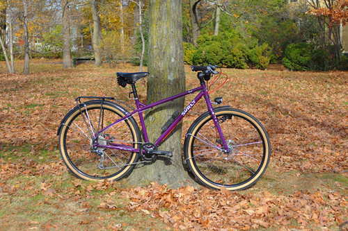
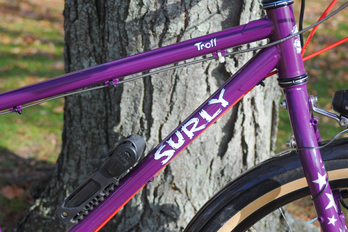
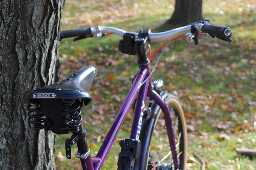
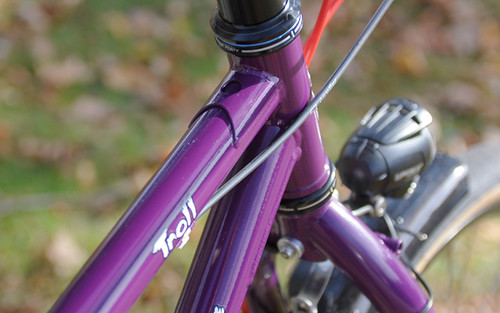
Surly Troll 650B

While Surly offers a range of practical, attractive, versatile bikes that riders everywhere love, none of them I find particularly appealing. Instead, I seem to be drawn to their weirdest and most extreme creations: their fat tired monsters. So naturally, when I saw Susan's new Surly Troll, I was delighted. Sure, it wasn't a Pugsley, but it was nonetheless glorious.


Surly Troll 650B

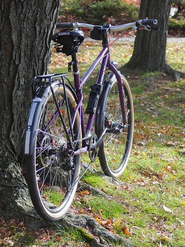
The Troll is a 26" wheel steel mountain bike with clearances for 2.7" tires. Built with eyelets for fenders and racks, it can also be set up as a commuter or utility bike, as well as an off-road touring bike.


Surly Troll 650B

Susan built it up for all of the above, converting it to 650B while she was at it.


Surly Troll 650B
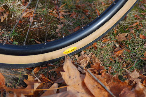
The tires are of course the 42mm Grand Bois Hetres. I realise now that I forgot to ask why Susan chose this wheel size, so normal it has become around these parts.


Surly Troll 650B

The Troll frame can be set up with cantilever/v-brakes or disc brakes - though I think the 650B conversion leaves only the latter option.


Surly Troll 650B

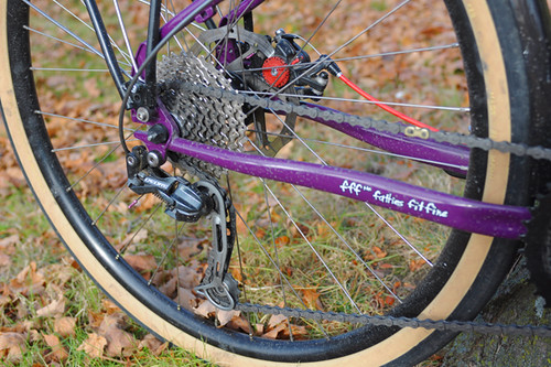
The Troll features interesting dropouts that I have not seen before. They are horizontal and resemble track ends, yet made with a derailleur hanger, making it possible to build the bike up with either hub or derailleur gearing.


Surly Troll 650B

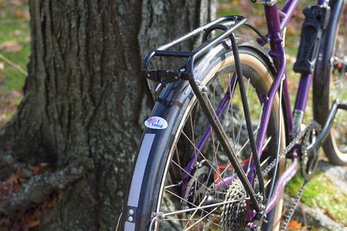
Susan has the bike outfitted with fenders, the Tubus Fly rear rack,


Surly Troll 650B
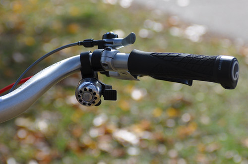
the slightly swept back Metropolis handlebars,


Surly Troll 650B

dynamo lighting,


Surly Troll 650B

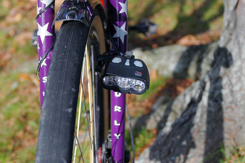
and one of those crazy super-bright headlights that point down to illuminate trails at night, powered by a battery pack.


Surly Troll 650B

There is something about the way this bike is set up that seriously excites me. I look at it, and I want to do "that" kind of riding, whatever that is. An overnight tour along pitch black dirt trails maybe?


Susan encouraged me to try the bike, and I did. The brief test ride proved to be surprisingly informative. The bike rode smoother than I expected.Very nice in fact. The Troll is not a lightweight bike, and it is not fast on the road. But it felt maneuverable in tight spaces and was not as difficult uphill as I expected. The stepover of the frame felt lower in practice than the images suggest, making it easy to hop off the bike without having to swing my leg over the back (I should note that I rode the bike with the saddle about an inch higher than shown here). There was no hint of toe overlap even with the 650B wheels. The disc brakes worked well, though I tried them in a very limited capacity.


Surly Troll 650B

The one drawback of this bike for me was the high bottom bracket (40mm BB drop on the frame), which made it difficult to get the saddle height where I wanted it. I like to be able to put a toe down when stopping without getting off the saddle, but the frame geometry + 650B conversion made that challenging to accomplish with full leg extension. However, I think that with the 26" wheels the bike was originally designed for, it should be okay. I could also try converting the Surly Ogre(a 700C version of the Troll) to 650B. Its 68mm BB drop should be just right for getting the saddle where I like it.


Surly Troll 650B

But of course I am just aimlessly fantasising here. I understand very little about mountain bikes and even less about their monster variations (still trying to figure out what exactly a suspension-corrected fork is). Still, I think that one excellent use for a machine like this could be as a winter bike. The Troll is not quite as extreme as a Pugsley, but neither is it as bulky. If fitted with 26" wheels and fat studded tires it could be just the thing for snowy Boston winters. With the frame priced at $500 MSRP, some strategic budget component choices could make for a fun and functional build.


Surly Troll 650B
Susan purchased her Troll frame fromHarris Cyclery, where she works as a custom fit specialist and lead salesperson. Naturally, she built it up herself, with parts she "had lying around." I hope she enjoys her cool new bike, and I thank her for letting me try it!

Thursday, October 27, 2011

Jack in the Pulpit


We're lucky enough to have more than one type of Jack in the Pulpit growing wild on our property. This is the most common, Arisaema triphyllum spp triphyllum. (Triphyllum = three leaves.)


Technically speaking, the "jack" is the spadix, and the "pulpit" is the spathe.


One of these days I'm going to memorize plant anatomy so I don't have to look it up all the time. I always feel dumb when I ask a question, and the answer involves so many technical terms that I feel like Gilligan, with all the Professor's lofty knowledge floating away right over my head.

At that point I never can decide the best course of action:
1) Nod and act like I understand,
2) Look confused and hope the expert will realize that I don't understand,
3) Admit outright that I don't understand, or
4) Look around frantically for another interesting flower, so I can shout "Ooh pretty!" and run away just as soon as the expert's lips quit moving.

Usually I opt for something between #1 and #2. "Hmm..." combined with a thoughtful look -- neither too confused nor too satisfied. A look that should convey, "Although I'm not a total idiot, I didn't quite catch your meaning, because obviously I'm not as smart as you are."


Here's Arisaema triphyllum ssp quinatum. I could only find one that was in bloom already.


Up close and personal.


There is another type here, but I couldn't find it blooming yet, so I'll write a "part 2" later.

Jacks are easy to confuse with Trilliums sometimes, especially before they bloom. The lighter colored leaves in the lower portion of the photo are Jacks:


In a garden I toured recently, the owner showed us what she called a "Japanese Jack in the Pulpit":


See how long the spadix is? Note my friend's fingers at the top of the picture below. She's holding the tip of the spadix! And that's the spathe way down on the ground, underneath the leaves (that look more like our Green Dragon's leaves).


I believe this variety is either Arisaema urashima or Arisaema thunbergii. (They're similar.)


-----

More information:

Wildwood Park's look at Jacks.

Primrose Path's page on American Jack varieties.

Paghat's Jack in the Pulpits and Cobra Lilies.

Arisaema Info.

International Aroid Society.

Sunday, October 23, 2011

Just Another Sunset...

These pictures almost weren't taken. As I was sitting at the picnic table at the Sebastian Inlet State Park Campground, getting eaten up by the tiniest little critters I have ever seen, I decided to go for a walk. I usually take my camera but for some reason didn't this time. As soon as I got to the road and saw the clouds over the water, I turned around and went back for it.

Interesting clouds. Nice, yes?
But I didn't think the sunset was all that spectacular.
I should have known better.
4:53 p.m.

But then I walked further down the road.
And the sun got lower.
And the clouds changed.
And I zoomed in a bit.
5:04 p.m.

A change of position and I zoomed in a bit more.
5:06 p.m.

Just a little further down the road.
5:14 p.m.

It just got better with each passing minute.
5:17 p.m.

And then it was over.
5:22 p.m.

Day is done, gone the sun,
From the lake, from the hills, from the sky;
All is well, safely rest, God is nigh.

One version of the History of Taps

I can't pass up a good sunset. Especially one that combines clouds and water. The perfect subjects. Mother Nature showing off yet again.

Just as a side note, the only “adjustment” made to these pictures was to resize them for posting to the blog. The colors and contrasts are just as they were captured by the camera. All I did was press the shutter button. They are, quite simply, Mother Nature at her awesome best!

Posted from the Brevard County Public Library, Melbourne Branch. Thanks to their free Wi-fi.

Two days in Vantage ..

Ian and I had planned to go to Squamish for a bunch of days. However, the forecast was not favorable for any of the "local" climbing areas. By Monday, Ian wasn't feeling well, and we decided to make it a two day trip to the Frenchman's Coulee area. Since I don't seem to enjoy climbing there, this didn't make me feel great about the trip before going, but I kept my hopes up that we'd have a good time.

When we arrived, the skies were gray, with a light wind. We headed to Sunshine Wall so I could help Ian finish his project of climbing all the sport climbs at Sunshine (and the Feathers.) Once there, I believe we "warmed up" on Throbbing Gristle(5.9). Ian led it and I followed. It was technically easy for a 5.9, but strenuous. I fell and hung at one point. I cleaned the anchor, and we moved on to the next objective: Air Guitar.

Right around the corner is Air Guitar(5.10a), a route with a little history. (Goran Kropp died from a fall on Air Guitar.) Ian sort of psyched himself out of doing this one in the past due to that reason. He climbed it, and sewed up the middle section a bit before he ended up leap frogging protection near the top, then running it out when out of gear. You should include two #3s and two #4s in a rack for this climb. (One guide book even says a #5 if you have it, but I think two #4s will do.) I had Ian leave the gear in for my climb. I cruised the lower 2/3s of the climb then the crack got to off hands for me. I didn't have a good jam to move up on, and took a fall trying to go for a higher hold. After a few attempts, Ian gave me the advice to go deep into the crack for a jam. It worked. I basically wound up jamming my forearm, and it gave me enough purchase to make the next hold. That got me up to a big ledge, where what I would call the final crux moves waited. Above the ledge the crack was wider and was either fists or off-width depending on your body size. I couldn't manage to get decent fist jams, and ended up arm barring the last section with a few falls to reach the chains. Since we had the top rope set up, Ian climbed it again, and then I gave it another lap where I struggled more on the lower 2/3s and had an easier time with the off hands section.

Ian on Air Guitar

At this point the wind was picking up, and it was trying to rain on us. Ian and I huddled down for a bit hoping it would pass and then decided to head back to the car area and possibly climb at The Feathers. We took a long scenic way back admiring the flowers on top of the mesa while hiking.

Desert Flowers

Before we got back to the car, we decided to climb at Zig Zag wall. Neither of us had before, and it was about time. So we headed over to Unfinished Business (5.8) as our first route over there. Ian then told me it was my turn to lead, so I led up the route. He wanted to see me climb at my limit, which that route technically wasn't, but was challenging for having smaller holds after we had been doing laps on Air Guitar. I on-sighted the route, and then Ian pink pointed it. He commented about the strenuousness with the small holds and congratulated me on a nice lead. We spoke with a few women about looking at their newer guidebook, then decided on a .10b route nearby. (I think it may have been called Group Therapy?) Ian led it nicely, then I thrashed up it to the chains. (Actually I wasn't that thrashy, just in one section.) We called it a day and ate dinner and hung out in the car before camping. (It had started to rain around 6pm, but we decided to stick it out to see what the next day would bring.)

We woke up at 6:15am and Ian promptly went back to sleep. I took a walk down to the Columbia on the road and just enjoyed the smell of the sage, and the desert morning. When I arrived back at the campsite, Ian was topping out from a free solo of Where the Sidewalk Ends (5.1). We got in the car to get him his morning coffee.

When we got back we headed to The Feathers in an effort to complete his project there. He wanted to start with a warm up on The Uprising (5.8), probably the nicest route at The Feathers. However, he wanted me to lead it. I was intimidated by the first bolt being 15' off the ground and backed off one move from it. Ian led it, and then I pink pointed it afterward. I told him that it was a little too stout of a lead for me to warm up on.

We headed through the notch and geared up for I'd Rather be Skiing at 49° North (5.10b). Ian stated to me that this was still not finished by him due to a somewhat scary clipping issue at the 4th and 5th bolts. (There is a potential for falling on a ledge if falling at that point.) It turns out that is the crux of the climb where it is slightly overhanging and has some awkward foot placements. Ian led it in fine fashion, and I cruised to the crux, and then thrashed a bit trying to overcome it. It mellowed out above that point and I cleaned the anchors.

The next target was Hardening of the Arteries (5.10c). This was another route with a high first bolt which has caused Ian trouble. Although after climbing it, I'd say the crux was between the 2nd and 3rd bolt for sure. Ian led the route with no issues, and I climbed it well to the crux where I got pretty pumped trying to pull through the steep moves before it mellows out again near the top. We left the rope up and allowed a Canadian guy named Peter to top rope the route. Then Ian climbed it again to clean the anchors.

Peter at the Crux on Hardening of the Arteries

The wind picked up again, and we sat in the car for a bit eating lunch and hoping it would subside. Ian had only one route left to complete his task, but neither of us was feeling great about going out and tackling it. So we hiked over to it, and looked at it and proceeded to pack the car and leave for Seattle.

Overall, a great trip. I feel I need to step up the next time I climb with Ian. I usually feel content following harder stuff, but want to start leading some harder stuff too. Perhaps next time.

Saturday, October 22, 2011

Route updates and more incidents

There are a number of climbing conditions updates now that the mountaineering rangers are regularly patrolling the standard routes. The Gibraltar Ledges, Emmons, DC, and Kautz were all climbed last week and we still welcome your reports if you're out and about...

This weekend went by without a mountaineering "accident," but their were "incidents." The first one involved three climbers who separated while descending from high camp on the Kautz Glacier. Two climbers (the faster pair) took off hoping to wait (relax) in the parking lot for their buddy. Can you guess what happened next? After spending much of the day wondering where their "teammate" was, the climbers finally contacted the NPS hoping to initiate a search. Sparing you the details, the third climber eventually showed up on his own many hours later. During which, his buddies were sent out to retrace their descent. Free advice: if you set out as a team, stick together. This is especially the case on descents that involve glacier crossings and cloudy/whiteout type weather.

And once again, we had another team use a cell phone to call their emergency contact and 911 for information and directions. Thankfully, the climbers worked out the issue before the NPS had to dispatch a climbing ranger team. Really, be prepared to sit out bad weather (which is common) on Mount Rainier, or become fodder for this blog. ;)

And speaking of cell phones, I've been getting a few questions about the "preferred" cell phone provider on the mountain. Truth is, I don't know. I think that each service does better in some places and elevations than others. That said, I'd be curious to get your comments on where your cell phone has worked and where it didn't (we know they work well on Liberty Ridge BTW). If you've used one while climbing (it can
be fun to call a friend while on the mountain) send me your comments so that they can be shared with other climbers.

The last and most significant mountain "related" news involves a search for a missing day-hiker on Eagle Peak. A 47 year old man didn't return from his hike last Saturday. I suspect that there will be more information released on this issue if things don't get resolved soon, stay tuned.

And if you're wondering, the opening photo is from the now famous Camp Schurman toilet seat. Dmitry Shapovalov's wanted to share the view with all of you. But if you head up there today, don't expect to see this unless you leave the NEW door open! Let's hope that this one makes it through the summer.

Thursday, October 20, 2011

Grand Canyon :: Bright Angel Trail to Indian Gardens

Prior to our little adventure yesterday we had gone to the Backcountry Permit Office to see what was available for an overnight trip. Somehow, Sue and Fred had talked me into a little backpacking hike and an overnighter. It really didn't take much convincing on their part as I was ready for a little adventure. Sue and Fred have hiked all the way to the river previously, spending a night at Phantom Ranch, then stopping off a second night at the Indian Gardens campground, making the trek to the top the following day. They have also done a lot of hiking and backpacking to various other places. They had also “trained” for this trip. So they were “old pros” at this backpacking thing. Me? Never backpacked. Never slept under the stars. There's a first time for everything!

As it turns out, there was a spot open at the Indian Gardens Campground for the next day, Tuesday. We were warned that there was a chance of precipitation Monday afternoon, possibly even some snow Monday night. We went ahead and made the reservation anyway.

Monday afternoon, after our return from Cedar Ridge, the temperature dropped dramatically. It had started raining in the late afternoon but that rain quickly changed to snow! Big flakes. Wet flakes. Lots of them. At first it didn't stick, but we soon noticed it accumulating on the branches of trees. By the time we went to bed Monday night, there was about two inches of snow on the ground. And it was cold. It got even colder during the night. And the snow was still there on Tuesday morning.

The scene we awoke to on Tuesday morning.

It was pretty, but we really could have done without it! I guess Mother Nature just wanted us to be able to experience all facets of the Grand Canyon.

By the time we had breakfast and double checked to see that we had everything, the sun had come out. It was about 8:30 when we left for the trailhead. Fred dropped Sue and me off, parked the car in the overnight lot, and returned within a few minutes. Then we walked to the trailhead. When we got to the Canyon, another surprise awaited us!

Fog! Filling the Canyon! Yes, snow, we had expected. But fog? One amongst our party, who shall remain nameless (not me), wasn't sure that we should continue. It would be too slippery. We couldn't see. But the other two of us took the positive attitude (or perhaps, were a little crazy) “It will get better. The fog will go away. The snow won't be very far down.” On we went. This picture was taken at 8:42 a.m. just beyond the first turn into the canyon.

Sue and Fred at the first tunnel, just .18 miles from the rim and ten minutes into the hike. The tunnel is visible in the previous photo. It was slow going. It was slippery. We took our time. Others had gone down that path before us, so it had to be okay, right?

The view of the rim from the trail, 20 minutes into the hike.

One of the worst patches of the trail, about 30 minutes into the hike. Beneath that fresh layer of snow was a very thick layer of slippery ice. This section of the trail gets little, if any, sun.

To be continued... part two

Monday, October 17, 2011

Bradgate Park to Beacon Hill and back via Ulverscroft Priory

With Harry. Weather a bit grey to begin with, fine drizzle, then muggy, then cleared. Great views but hazy. Muddy in woodland. Just over 10 miles (with our detour!) Just over 1000 feet of climbing - not all at once.


I hope it's crystalline in clarity next time I do this walk!


We parked at Bradgate Park in Newtown Linford, and after a kick-start cup of coffee, went through the main gate to the drive, took a path immediately to the left and headed up hill towards Tyburn Copse. From the right hand side of this copse the obelisk monument to the dead of the two World Wars is visible directly north.


Onward and upward to the memorial obelisk - a hazy, misty start to the walk.


Misty landscape behind Harry


And more mist behind 'big boots'!

We followed the path to the right of the copse and up to Old John, the tankard-shaped 18th century folly at the highest point of the park.


Scaling the heights


There's a toposcope here which claims views as far as Nottingham Castle and Burrough Hill. On a clear day . . .

We left Old John and walked downhill to the north-west corner of the park.


Downhill from Old John

We continued past the toilets, downhill and through the car park, to a road junction. We took Benscliffe Road for a couple of hundred yards, before turning right along a footpath waymarked 'Leicestershire Round'. This goes downhill through Rough Hill Wood, then continues on to a magnificent golf course. The path is clearly marked as it crosses several fairways.


A fine crop of crab apples


The sweep of the greensward


I hope the ducks manage to dodge the golf balls

After the golf course, the path is quite clear as it goes over a field and on to a track. The track joins a road where we turned right and walked downhill toward Woodhouse Eaves.

There are two possible routes from here - I think we chose the one where it's easier to wander off track.


We took the first footpath off to the left. It leads up and along the edge of two fields, before cutting diagonally across a grassy meadow. By one of the hedges I spotted my first serious blackberry pickers of the season. The path comes out at a road and this is where we made our unintended diversion. I blame lack of looking at the map, and being distracted by an obvious gate and continuation of the path just opposite.


We visited the Broombriggs Farm trail, which is well supplied with benches and decent views to the east - and cattle.


Wot? No kitchen sink? Snack break at Broombriggs.

We returned to the entrance and turned along the road (left this time). At the T-junction with beacon Road we crossed the road and a track to join the wide path which leads gradually to the summit.


Trig point on Beacon Hill - great views all round


Another peak conquered

forget the car park 100 yards down hill!


Radcliffe power station in the distance?


Cattle grazing near the summit


Blooming heather adds to the moorland feeling


We went downhill to the car park, and turned right, past the toilet block. The gravelled path forks left and heads downhill through the woods. When we reached a rusty charcoal burner

we walked round behind it and took a narrow short path which comes out at a crossroads.


We crossed over and took the road towards Copt Oak. A few too many cars, but it's a short distance. After 300 hundred yards we turned into a lane just before a wood. There's a remote-operated gate for cars, but a path for walkers at the edge.

When the wooded area ends, the path forks off to the right and heads south-west along the edge of several fields. When we reached Ulverscroft Lodge Farm, we turned left along the path which joins a drive leading past Ulverscroft Pond to the remains of Ulverscroft Priory, with its moat and fishponds.


The drive continues until it reaches a road junction. Here we crossed over into Ulverscroft Lane. This was pleasant walking, as it is quiet and shaded by trees. Continue past the wonderfully named Polly Botts Lane.


After around three-quarters of a mile, there is a footpath sign for Newtown Linford. The path leaves the road on the right hand side, then you take the left hand fork across a field just after a stile. It was very muddy in places, especially through the woods, but easy to follow.


The only slightly tricky part, is just after you pass a ruined building to the left. Here you have to turn left and very soon go over a footbridge then head for Newtown Linford which can be seen ahead. This is an exceptionally attractive, well-kept village. We walked through, past the pubs and back to Bradgate Park and a large pot of tea with cake.


Thanks to James Rhodes and Walking Britain for info about this walk