Tuesday, January 31, 2012

Weekend Game Cam

Lots of coming and going in the woods...


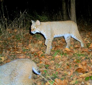
Pair of bobcats! I've noticed that at least one of the local bobcats is sort of sway-backed... I think that's her in the foreground.


Nice coyote! Almost as if he were posing.


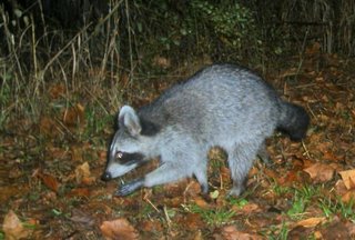
Racoons are still the most common visitor. I didn't realize that their hands were hairless like that, but it makes sense.


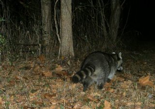
I'm not sure if he's heavier than the previous one, or just fluffed up in the cold.


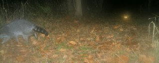
Click the picture for extra eeriness!


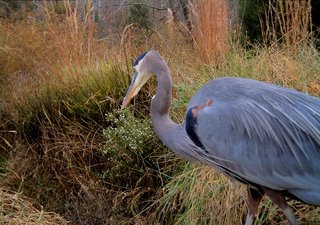
Hubby moved the camera, hoping to catch a beaver or otter on this path down to the pond. No luck, but we did get this picture of a Great Blue Heron. (Nice, but the camera is more focused on the background.)

He's moving it again today, in quest of otters.

Monday, January 30, 2012

"Gasoline Rainbow" 28


My first climb at the grade. Gas Rain is probably still my favourite line at Coolum, it's a second pitch start, steepening up after the second bolt. I took so many plunges from the crux of this route, some of them beauties with an armfull of rope out to clip, just falling into clean air.

36 attempts finally acheived a tick.


photo: Phil Box

Sunday, January 29, 2012

Wordless Wednesday - Not Your Normal Portrait

Carrie and Tami. Summer of '81. Digitized ...
Copyright © 1981/.. by Rebeckah R. Wiseman

Saturday, January 28, 2012

Fiddling with Handlebar Height

Dialing in the Mercian

I've been riding my fixed gear bike ("Mercy Anne") fairly regularly since we put it together in September. Not long rides, but frequent short rides. Unlike my geared roadbike, I never stopped riding the fixed gear over the winter. And of all my bicycles with drop bars, for whatever reason this one is the most ridable in regular clothing, so if I don't feel like wearing cycling clothes on a short ride I don't have to. I've even ridden it in skirts and semi-high heels a few times; it is surprisingly tame and versatile.


Maybe it's because of that versatility that I find myself constantly fiddling with this bicycle's handlebar height. It's not that my positioning doesn't feel right, but more like all the positions feel equally right and I can't decide which one to settle on. When we first assembled the bike, I had the stem "slammed" and the bars considerably below the saddle. It felt perfectly comfortable, but over the winter I started riding in the city more and decided to experiment with being more upright. So I raised the bars to saddle height, and that felt great also. Then one day I lowered them again just for the heck of it, and that too felt good.


Strange that on other bikes I feel a distinct "sweet spot" as far as handlebar height goes and on this one I do not. Not sure how many times I've raised and lowered the bars now thanks to the easy up/down adjustability of the threaded stem, but it's probably time to settle on one position and stop the madness. How do you decide on handlebar height, and do you tend to fiddle with it after the initial set-up?

Friday, January 27, 2012

Snow Drifts on Hungry Jack Lake


Here is another shot from my afternoon along the Gunflint Trail yesterday. This was taken with my Canon 100-400mm lens from the Honeymoon Bluff overlook.

Thursday, January 26, 2012

Three Rivers Petroglyph Site


This morning we (my friend Roger and I) left Bosque del Apache National Wildlife Refuge and headed to our next destination: White Sands National Monument. Our plan was to ring in the new year camping under the full moon at White Sands but along the way were a couple areas of interest, most notably the Three Rivers Petroglyph Site. The petroglyph site is about halfway between Carrizozo and Alamogordo on the way to White Sands. Since I am Native American and my friend Roger and I are both interested in anything to do with Native American history, we wanted to stop and visit the site.


(Click on each image to view a larger version with more detail)


The petroglyphs are carved into an outcropping of boulders that lies on the Tularosa basin, with a terrific view of the broad valley and the Sierra Blanca mountains to the East, the San Andres mountains to the West. The petroglyphs are thought to be the product of the Jornada Mogollon people between about 1000 and 1400 A.D. It is also a very petroglyph-dense site, with (according to BLM materials), over 21,000 to be found in the area. Roger and I walked around the area and took pictures of several of the more prominent petroglyphs, then it was time to continue on to White Sands.


(Click on each image to view a larger version with more detail)

Wednesday, January 25, 2012

White Sands National Monument

From the title of this post and my post the other day, you've probably figured out that I'm not in Louisiana any more!


Tuesday morning (January 3rd) after spending a delightful two weeks over the holidays with extended family, I departed for points west once again. I zipped through Texas (well, it's not really possible to “zip” through unless you're traveling across the panhandle) in two full days of driving spending one night at Lake Mineral Wells State Park southwest of the Dallas metro area on U.S. 180.


It was a leisurely drive from Mineral Wells along U.S. 180 all the way to Hobbs, New Mexico where I spent the second night (January 4th) at the Harry McAdams Campground on the northwest side of Hobbs.


Thursday (January 5th) was an even more leisurely and interesting drive, going north from Hobbs to U.S. 82 through the high desert and over the Sacramento Mountains to Alamogordo. In spite of the dire warnings on numerous signs on the way to the mountains, the drive through was really quite nice. The grades weren't nearly as steep as some I've been on. It was a gradual uphill climb through a surprisingly forested area and the descent was not bad at all.


That night I stayed at Oliver Lee Memorial State Park, 15 miles south of Alamogordo, at the base of the mountains overlooking the city. The next morning (Friday, January 6th) I drove the short distance to White Sands National Monument arriving just as the visitor center opened at nine o'clock. After watching the very informative movie and viewing the exhibits, I drove on into the dune field.


The sand at White Sands is unlike any that I've ever seen before. The dunes are hard packed and easy to walk on but the texture of the loose sand in the top layer is unusual. Most sand is rather coarse but this sand was so fine and soft – it has a consistency somewhat like talcum powder, it is that fine. When you squeeze it in your hands it sticks together but then easily crumbles. Very cool stuff. And very, very White!


I walked the one-mile nature trail through the dunes and the boardwalk trail then drove on out to the end of the road. The last few miles of the road are unpaved – they bulldoze a road through the dunes with ample areas for pulling off to the side and large parking areas so you can explore the dunes on your own.


Stopping at the end of the road, I strolled through, around, and over the dunes for about 3 hours. It was amazing how easy it was to walk on the dunes. It was also very quiet, few other people were out and about. In fact, I saw no one else while on my walk until I was almost back at the van. Every so often a jet plane from the nearby Air Force Base would fly overhead. But the quietness seemed even quieter once it passed by. It was a cool 36 degrees when I entered the park but with the sunshine and no wind whatsoever it felt much warmer. Though it was short, I very much enjoyed my visit to White Sands.


Plants take root in the dunes and when the dunes move on, these structures are left behind. They are very hard-packed and feel almost as hard as stone, except when you move your hand across the face of the mound it easily crumbles into soft dust.


It's hard to show it, but the top layer of sand is extremely fine and soft textured.


There were a few remnants of the last big snow storm (those white chunks in the center).


This was the only person I saw during my three-hour walk on the dunes. The bright white area on the left side is part of what remains from the last snowfall.


The top of this dune, where I was standing was about 35 feet high.


I saw very few areas of ripples like these, which surprised me. There was virtually no wind blowing on the day of my visit so these had been there for awhile.


The Sacramento mountains off to the east. Snowfall in the area has been light thus far this year, only the highest peaks are snow covered. All photos were taken on Friday, January 6th.